
Electrical Balance of Plant of Thermal power plant
2025-08-14T22:12:56  read more


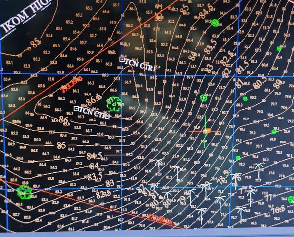

Contour Survey Drawing: Before start of any project, it is necessary that the Plot of the project is properly assessed through topo contour survey using Total station or DGPS device. Levels at different portions of the Plot allows the engineers to decide the extent of land cutting, , filling, grading, slope protections, plant layout, to make policies to overcome challenges in construction of buildings, structures and plants. The contour survey drawing shows the spot heights at 5 or 10m interval to closely observe the undulations in the existing ground. This exercise also helps to (1) locate the geographical coordinates of the Plot so that it can be plotted in scale in Google earth or similar software, (2) decide the approach road direction from the Plot to the main road, (3) decide direction and clearances of incoming or outgoing transmission lines from the plot, (4) decide overall size and shape of the plant depending it's location and vicinity with township or congested locality. Satcon has a team with necessary devices to carry out topo contour survey of large plots. 15 acres of land can be surveyed in one day using our DGPS device. We have two decades of rich experience in carrying out survey of substation plots or transmission line right of way in India and other countries.
We hate spam too.